Methye Portage
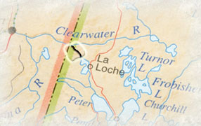 The height
of land and plateau that separates Lac La Loche from the Clearwater
River marks the continental divide between two great river systems.
To the north, the Clearwater River leads to the Athabasca and Mackenzie
rivers, eventually flowing to the Arctic Ocean. Across eight miles, a
beaver pond and small stream to Lac la Loche are the headwaters of the
mighty Churchill River that traverses two provinces and flows into HudsonÕs
Bay. The trail between the two systems is known as Methye Portage.
The height
of land and plateau that separates Lac La Loche from the Clearwater
River marks the continental divide between two great river systems.
To the north, the Clearwater River leads to the Athabasca and Mackenzie
rivers, eventually flowing to the Arctic Ocean. Across eight miles, a
beaver pond and small stream to Lac la Loche are the headwaters of the
mighty Churchill River that traverses two provinces and flows into HudsonÕs
Bay. The trail between the two systems is known as Methye Portage.
To fully appreciate the significance of Methye Portage, one must try to look at it through the eyes of a Dene person in the late 1700s. Denedeh, the vast homeland of the Dene Nation was insulated on all sides from outside intrusion. The frozen arctic barren grounds protected them on the north and east, and no easy access was available from the south. There was a way, however, like a secret passage to the Dene home. This was the short distance between the headwaters of the Churchill and the Clearwater River. Until 1778, protected from outside influence, Denedeh was secure.
That year Peter Pond, on the advice and guidance of local people, crossed the Methye Portage to the Clearwater. This opened up the rich fur country of the Athabasca to the merchants of Montreal and marked the end of the ancient confederation of Denedah. Smallpox struck in 1781. It is said that 90% of the Cree and Dene population died at that time.
The fur trade, however, carried on and all the furs of the Athabasca and Mckenzie areas traveled over Methye Portage. Even today, the path is wide enough for a wagon to use. Many voyageurs passed over the portage with countless tons of furs and trade goods on their backs. Today, the track is worn deep where they walked.
The Methye Portage also made possible the charting of a route across Canada by Alexander Mckenzie in 1793. In the United States further south, Lewis and Clark did not reach the pacific until 1805. History commends these efforts as discovery.
From an Aboriginal perspective, these routes were known and trade was carried on thousands of years before the arrival of Euro-Canadians. Copper artifacts dated at 3500 Ð 5000 BP have been found at sites along the Clearwater River. The artifacts originated from the Great Lakes region to the east, and would have arrived at their final location by crossing the arduous Methye Portage.
Archaeological evidence from sites such as the southwest shore of Brabant Lake suggests continuous use of the Churchill and its tributaries from pre-historic times to present. Stone materials used for making tools found at the Brabant site are not local to the area. This evidence suggests a trading network that was in existence before the fur trade era.
The Churchill can be understood as the ancient equivalent of the Trans Canada Highway, and its tributaries being secondary roads. From an Aboriginal perspective, the Churchill River and area has always been a bountiful homeland that provides for all the wants and needs of a complex society.